Swiftpack.co is a collection of thousands of indexed Swift packages. Search packages.
See all packages published by lukepistrol.
lukepistrol/LPMapView 0.6.1
A SwiftUI wrapper for a MKMapView
⭐️ 18
🕓 1 year ago
iOS
.package(url: "https://github.com/lukepistrol/LPMapView.git", from: "0.6.1")
![]()
![]()

![]()
LPMapView
📖 See the full documentation here.
A SwiftUI wrapper for MKMapView.
Overview
This offers a couple more features compared to SwiftUI.Map.
Usage (iOS 16)
@State private var coordinateRegion: MKCoordinateRegion = ...
@State private var items: [MapViewAnnotation] = ...
MapView(
region: $coordinateRegion,
showsUserLocation: false,
userTrackingMode: .none,
annotations: $items
)
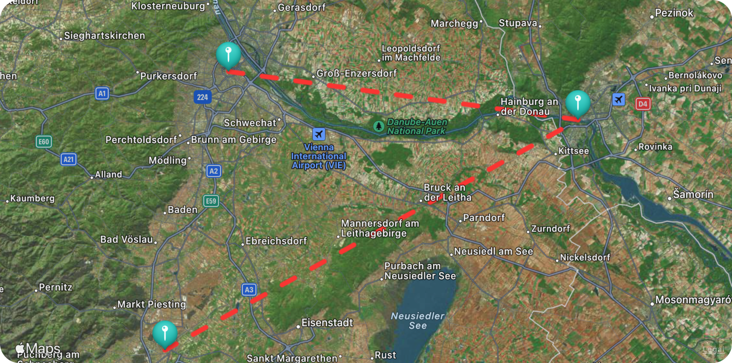
.mapDisplayRoute() // connect annotations with lines
.mapRouteStyle(.dashed(5, tint: .red) // Use a dashed line
.mapAnnotations(.visible, tint: .mint) // show annotations with custom tint
.mapConfiguration(.hybrid) // use the hybrid map style
The above example usage would deliver a map view similar to this one:
Usage (iOS 14 & 15)
@State private var coordinateRegion: MKCoordinateRegion = ...
@State private var items: [MapViewAnnotation] = ...

LMapView(
  region: $coordinateRegion,
  showsUserLocation: false,
  userTrackingMode: .none,
  annotations: $items
)
.mapDisplayRoute() // connect annotations with lines
.mapRouteStyle(.dashed(5, tint: .red) // Use a dashed line
.mapAnnotations(.visible, tint: .mint) // show annotations with custom tint
.mapConfiguration(.hybrid) // use the hybrid map style
Modifiers
There are a couple of modifiers available for configuring additional options for the map view.
mapDisplayRoute
Declaration
func mapDisplayRoute(
  _ visibility: MapViewVisibility = .visible
) -> some View
Parameters
visibility: Whether or not the route will be visible.
mapRouteStyle
Declaration
func mapRouteStyle(_ style: MapRouteStyle) -> some View
Parameters
style: The route line style to use.
mapAnnotations
Declaration
func mapAnnotations(
  _ visibility: MapViewVisibility = .visible,
  tint: Color = .red,
  calloutEnabled: Bool = false,
  fitInVisibleRect: Bool = false,
  animated: Bool = true
) -> some View
Parameters
visibility: Whether or not annotations will be visible.tint: The default tint color of the annotation. This can be overridden by settingMapViewAnnotation/tintonMapViewAnnotation.calloutEnabled: Whether or not to show a detail callout when an annotation is selected. Note that this will only work if the annotation has a title.fitInVisibleRect: Whether or not to automatically adjust map zoom to fit all annotations.animated: Whether or not to animate changes.
mapConfiguration
Declaration
func mapConfiguration(
  _ configuration: MapViewConfiguration,
  elevationStyle: MKMapConfiguration.ElevationStyle = .flat, // iOS 16 only
  poiFilter: MKPointOfInterestFilter = .includingAll,
  selectableFeatures: MKMapFeatureOptions = [] // iOS 16 only
) -> some View
Parameters
configuration: A configuration option defining the map style.elevationStyle: Defines how elevation data is handled when rendering the map view.poiFilter: A filter that includes or excludes point of interest categories from a map view, local search, or local search completer.selectableFeatures: Describes which selectable features the map responds to.
mapUserInteraction
Declaration
func mapUserInteraction(
  zoom: Bool = true,
  scroll: Bool = true,
  pitch: Bool = true,
  rotate: Bool = true
) -> some View
Parameters
zoom: A Boolean value that determines whether the user may use pinch gestures to zoom in and out of the map.scroll: A Boolean value that determines whether the user may scroll around the map.pitch: A Boolean value that indicates whether the map uses the camera’s pitch information.rotate: A Boolean value that indicates whether the map uses the camera’s heading information.

GitHub
| link |
| Stars: 18 |
| Last commit: 31 weeks ago |
Advertisement: IndiePitcher.com - Cold Email Software for Startups
Release Notes
0.6.1
1 year ago
What's Changed
- [feat]: Option to disable animations by @lukepistrol in https://github.com/lukepistrol/LPMapView/pull/2
Full Changelog: https://github.com/lukepistrol/LPMapView/compare/0.6.0...0.6.1
Swiftpack is being maintained by Petr Pavlik | @ptrpavlik | @swiftpackco | API | Analytics